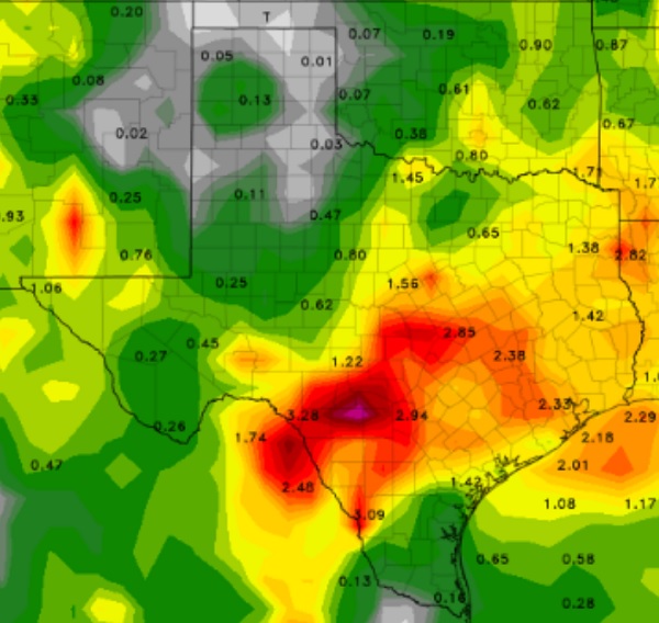
Rain is forecast to move into the KOXE listening area Monday night and stay with us, off and on, throughout the week.
From KOXE Meteorologist Randy Turner:
As of early Sunday morning – An upper level low, near southern California/Baja, is forecast to move into New Mexico by Monday which initiates rain and thunderstorms in our area by Monday night into Tuesday.
Following the same path as the first system is another upper level low which develops by Wednesday night in the southwest U.S. and moves slowly toward Texas through the end of the week.
These lows will tend to send rain making systems into our area periodically which is why rain is in the forecast daily through the upcoming weekend.
But wait, there’s more! A cold front will ease down into our area Thursday and Thursday night and that will further enhance the chance for rain. We may also have a high temperature Friday somewhere around 70-75 degrees.
Will it rain constantly this week? No. Off and on? Yes.
Most likely times for rain, as it looks on this Sunday morning are: Monday night, late Tuesday afternoon through Tuesday night, Thursday afternoon and Thursday night. Rain will also stay in the forecast Friday and Saturday.
How much rain this week? As of now the forecast models suggest 1 to 2 inch totals between Monday night and Saturday night in Coleman, Callahan, Eastland, Brown, Mills, McCulloch, Comanche and San Saba counties. Heavier totals between San Saba and Austin and from Goldthwaite to Waco. As usual, if you are in the path of a slow moving thunderstorm or two, your rain totals could be much more than the 1 to 2 inches suggested.
Stay tuned to KOXE this week, on the radio and through our weather videos on KOXE.com, for updates to this rainy weather pattern.
(the map shown is estimated rainfall totals by the GFS model between Monday night and Saturday)

